Proposed Knighton Neighbourhood Area Consultation
Feedback updated 13 Apr 2016
We asked
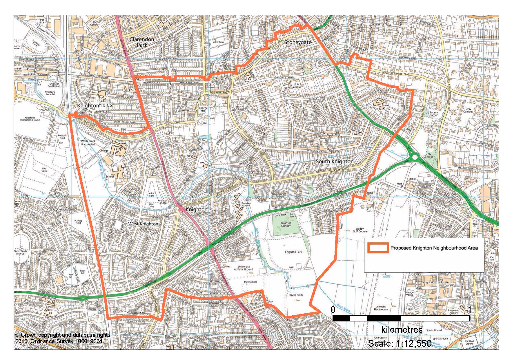
Whether the suggested boundary for the Knighton Neighbourhood Area was appropriate for the emerging Knighton Neighbourhood Plan and that the proposed area covered the correct school catchment areas, known local communities and geographical features that make up the area known as Knighton.
You said
Leicester City Council received a total of 33 responses during the consultation
period
- 58% of responses supported the proposed boundary
- 24% of responses where against the proposed boundary
-
18% of responses make general comments nether supporting or being against the proposed boundary.
We did
On 5 April 2016 Leicester City Council formally adopted a boundary for Knighton Neighbourhood area which was amended based on representations received during the consultation. The amendments made to the boundary were to include all of Birkdale Avenue and to exclude some properties on Knighton Lane East which form part Knighton Fields.
Overview
Leicester City Council has received an application for the designation of a Neighbourhood Area. The proposed area covers most of the Knighton Ward and is to be known as the ‘Knighton Neighbourhood Area’. All residents within the proposed area will or be soon receiving a letter notifying them of the proposal.
This is the first stage in the process of the Knighton Neighbourhood plan. A Neighbourhood Plan is a community-led framework for guiding the future development and growth of an area. The first formal step in the neighbourhood planning process is to consult the community within or close to the proposed boundary on whether the neighbourhood area submitted seems appropriate.
The plan has been proposed by the Knighton Neighbourhood Forum. See below link to their website :
As required by Regulation 6 of the Neighbourhood Planning (General) Regulations 2012, a copy of the application, a map of the proposed area and supporting documents can be viewed below. A high resolution version of the map can also be viewed by clicking on Large Map.
Those wishing to make representations can do by either using the form on this website or by emailing planning.policy@leicester.gov.uk
The consultation runs from 3rd September 2015 to 15th October 2015.
Application Form Designated Area
Designated Authority Statement
Areas
- Castle
- Eyres Monsell
- Knighton
- Saffron
- Stoneygate
Audiences
- Advocacy organisation
- All households
- All Public and Private Organisations
- All staff
- All Voluntary and Community Organisations
- Businesses
- Care home residents and their next of kin
- Carers
- Carers' network
- Children and young people
- Community organisations
- Couples
- Directors
- Disabled people
- Drug and Alcohol services
- Faith groups
- Families with children
- FE colleges
- Full-time and part-time workers
- Gypsy and Traveller community
- Heads of service
- Health services
- Managers, team leaders and supervisors
- NHS
- Older households (65+)
- Older people
- Partner agencies
- Police
- Professionals
- SCE staff
- Schools
- Self-help groups
- Service providers
- Service users
- Single people
- Sports clubs
- Third sector infrastructure groups
- Trade unions
- Universities
- User groups
- Voluntary organisations
- Working-age people
- Youth clubs
Interests
- Planning
Share
Share on Twitter Share on Facebook